 |
| Photo courtesy of the Spokane Vly Heritage Museum |
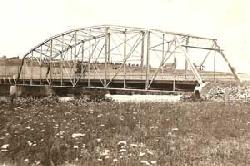
The steel bridge at Spokane Bridge is pictured in this 1913 photo. This bridge, which replaced four previous wooden bridges at the site, was built in 1911.
|
|
|
|
|
History — Spokane Bridge: An Inland Northwest original
10/31/2012 9:39:26 AM
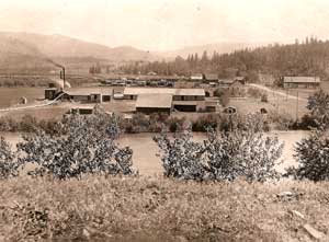
Photo courtesy of the Spokane Valley Heritage Museum
The Spokane River (foreground) remains a constant in this view of Spokane Bridge. The Cranston Box Manufacturing Co., built in 1913, is shown south of the river. The company milled, on average, a dozen railroad cars full of box shooks (the thin, wide boards used to build fruit boxes) per week. Everything in this photo, between the river and the present-day site of the Rockin' B Ranch in the far background, has given way to Interstate 90.
|
By Tom McArthur
For the Liberty Lake Historical Society
Before there was a Spokane, before there was a Spokane Falls, there was a Spokane Bridge - the first pioneer settlement in the Intermountain West. Most present-day residents of the area probably could not tell you what caused it to be, where it was, what caused most of it to disappear and where parts of it still are.
Let's take these one at a time.
What caused it to be?
Imagine yourself a feather, floating down the Spokane River from its headwaters at Lake Coeur d'Alene. After you pass through the dramatic gorge at Post Falls, you return to a leisurely pace as the river widens, the banks flatten and you begin to meander through Liberty Lake and onto the Spokane Valley.
This is where pioneers began to settle about the time of the American Civil War (1861-1865) - more than a decade before settlement would begin downstream at the next great falls, Spokane. Advertisement

The first pioneer to settle in the area was Antoine Plante. He first appeared in the written records of the area in 1852. Plante was typical of the early whites who came through here, attracted by the area's rich natural resources. Plante settled his family in a crook of the Spokane River, on the north bank (where Plante's Ferry Park marks the site today), in 1854. Plante's brother-in-law, Camille Langtu, settled directly across from them, on the south bank.
As the stream of trappers and miners through the area grew, all needing to cross the river on their way toward visions of silver in the mines of north Idaho, Plante and his brother-in-law saw a business opportunity right outside their doors. They opened a ferry business with fees of $4 for each wagon, carriage or vehicle with two animals attached (about $100 today) or $1.50 for a man and horse (about $35 today).
It didn't take long for others to see a business opportunity in helping travelers cross the Spokane River.
|
View it online
Enter these coordinates into Google Maps on your web browser to see the old Spokane Bridge site across the Spokane River: 47.698013, -117.051497. You can see where the 1911 steel version of the bridge crossed as well as the remnants of U.S. Highway 10 that meandered north and east from the bridge.
Genesis of Liberty Lake
A series from the Liberty Lake Historical Society, appearing in the first Splash issue of each month in 2012.
January: Geology of Liberty Lake
February: Coeur d'Alene Tribe
March: 150 years of Gathering, Recreation and Music
April: Indian Wars, Part I
May: Indian Wars, Part II
June: Chief Seltice
July: Tecomtee
August: Peter Wildshoe
September: Mullan Trail
October: Homestead Act
November: Spokane Bridge Crossing
December: Stephen Liberty
|
Was there really a bridge?
Yes, there really was a bridge at Spokane Bridge.
The first bridge across the Spokane River was built in 1864 and operated as a toll bridge by three business partners (Joe Herring, Tim Lee and Ned Jordan). It was strategically placed nearer the famous Mullan Road than Plante's Ferry, approximately where the new state line bridge was recently completed. The fee to cross was only $1 - no matter what you were bringing across. The bridge funneled people and equipment through the Spokane River valley up to gold and silver mines in the mountains of Idaho, Montana and British Columbia.
A town soon surrounded the new structure, first called Pioneer Bridge until most people just began calling it Spokane Bridge. It became the first settlement in a vast Inland Empire and boasted several firsts for the area: the first store, the first house, the first hotel and the first post office.
Bridge partner Tim Lee became the first postmaster of Spokane Bridge in 1866, stamping letters in his store south of the bridge. In 1870, the first census of the area counted 29 people here. Spokane Bridge became a stop on the Pony Express in 1871, connecting The Dalles, Oregon Territory, to Missoula, Montana Territory.
In 1872, Michael Cowley (who emigrated alone from Ireland at the age of 15), established a general store on the north side of the river. Years later, in his memoirs, Cowley described the early time of Spokane Bridge as "stirring days."
In 1880, the second census of the area counted 45 people here.
Truth be told, there have been five bridges at Spokane Bridge. The first four, built of wood, were successively washed away by seasonal high water. The fifth was built of steel in 1911.
In 1908, Joseph Humphreys established a farm on the south side of the river. He first built a little cabin and then added a house in 1910.
Spokane Bridge remained a viable town from its inception through the 1940s. In fact, when U.S. Highway 10 was commissioned in 1926 (from Seattle to Detroit), it used the bridge at Spokane Bridge to cross the river.
What is left to see?
Three pieces of Spokane Bridge remain today.
The easiest to see are the north and south concrete abutments from the 1911 bridge. Park your car at Gateway Park (state line exit 299) and take a short walk to the river. Here, you are standing in the middle of the old U.S. 10 where it crossed the Spokane River.
Look across the river and you'll spot the old Cowley place in the trees. It still holds a commanding view of Spokane Bridge and the old U.S. 10 from its perch on the north side of the river. The Cowley House is among the oldest surviving structures from the area's pioneer days. The property is fenced and used for storage.
Head back under the freeway, and you'll see the old Humphreys place, shaded by a grove of trees on your left - now the Rockin' B Ranch Event Center. The original 1908 homesteader's cabin and 1910 farmhouse are visible from Spokane Bridge Road. The Rockin' B Depot, part of the ranch's western melodrama set, is the only structure in the area that still bears a sign for where it was and where it is: Spokane Bridge.
Tom McArthur is the ranch foreman and historian for the Rockin' B Ranch at Spokane Bridge. He can be reached at ranchforeman@earthlink.net. McArthur previously was the communications director and historian for the Davenport Hotel. He has produced several historical documentaries for KSPS-TV, including "Remember When: Nat Park," and "Remembering Spokane."
|